this is a tornado on the run.
From Wikipedia, the free encyclopedia
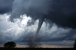
A tornado in central
Oklahoma. The tornado itself is the thin tube reaching from the cloud to the ground. The lower part of this tornado is surrounded by a
translucent dust cloud, kicked up by the tornado's strong winds at the surface
A tornado is a violently rotating column of air which is in contact with both a cumulonimbus cloud or, in rare cases, a cumulus cloud base and the surface of the earth. Tornadoes come in many sizes but are typically in the form of a visible condensation funnel, whose narrow end touches the earth and is often encircled by a cloud of debris.
Most tornadoes have wind speeds of 110 mph(177 km/h) or less, are approximately 250 feet (75 m) across, and travel a few miles (several kilometers) before dissipating. Some attain wind speeds of more than 300 mph (480 km/h), stretch more than a mile (1.6 km) across, and stay on the ground for dozens of miles (more than 100 km).[1][2][3]
Although tornadoes have been observed on every continent except Antarctica, most occur in the United States.[4] They also commonly occur in southern Canada, south-central and eastern Asia, east-central South America, Southern Africa, northwestern and southeast Europe, Italy, western and southeastern Australia, and New Zealand.[5]


Comments (0)
You don't have permission to comment on this page.